- Study Abroad
- / ielts
- / map wars reading answers
Map wars Reading Answers


Author
16-09-2025

We have given the Map wars Reading practice test and answers with explanations. These will help you evaluate your performance. It has 13 questions of four different question types. Go through this entire post to check Map wars Reading Answers and rectify your mistakes.
Check out our YouTube Channel to Practice Full-Length IELTS Reading Tests Daily

Table of Contents:
- Solution for Map wars
- Map wars IELTS Reading Practice Test
- Passage
- Questions
- Answers with Explanations
Solution for Map wars
In the table given below, you have the Map wars reading answers. Use them to evaluate your band score and performance.
Answer Table
| 28. projection | 32. M | 36. A | 40. C |
| 29. axis | 33. M | 37. B | |
| 30. perspective | 34. P | 38. C | |
| 31. compare | 35. M | 39. A |

Map wars IELTS Reading Practice Test - Exam Review
The Map wars IELTS reading answers are given. It will help you to take the IELTS reading practice test to challenge your reading skills. Diagrams are described in sentences, therefore, read the passage carefully to understand what is asked in the question. Do not exceed the word limit, or the answer will be considered wrong. Highlight or underline the keywords, which will help you in finding the answers quickly.
Passage
You have been given the Map wars reading passage below. Spend around 20 minutes solving this passage which consists of 12 questions. Read the passage carefully and swiftly before answering. We have also provided Map wars reading answers with locations.
Map wars
- A map of the world expresses a point of view. A correct model of the earth is a sphere - or an ellipsoid to be precise. Photographs of the earth from space provide comforting reassurance on that point. If you wish to know the relative positions of the continents and the oceans you should go out and buy yourself a globe and spin it around.
- But a globe cannot be pinned to a wall or printed in a book. For that you need a two-dimensional representation. This is where the problems start since you cannot project three-dimensional information onto a flat plane without making certain assumptions. The arguments between cartographers mostly concern what those assumptions should be.
- The simplest two-dimensional representation is a ‘cylindrical’ projection - what you get by wrapping a sheet of paper around a globe and simply transferring the information across. This means it indicates true north and south. So, Newfoundland is directly north of Venezuela and it appears that way on the map. East and west similarly are also indicated correctly. Such a map demonstrates what is called ‘fidelity of axis’.
- One of the longest-lived cylindrical projections was based on the needs of sixteenth century navigators. Gerhard Kremer, a Flemish mathematician, produced his view of the world in 1569. ‘Kremer’ translates to ‘merchant’ in English and ‘mercator’ in Latin. And the Mercator projection survives to this day in many books and maps.
- Mercator’s projection of the world also shows intermediate compass directions like north-west more or less accurately. So, it is possible to conclude from his map that Brazil is south-west of Liberia and if you plot a course in that direction you will eventually arrive at your destination. No wonder it was appreciated by the early explorers! If it can be used in this way a map is said to have ‘fidelity of angle’.
- But fidelity of angle is only achieved at a cost. To make it work, the further away you get from the equator, the further apart you have to move the horizontal lines of latitude. As these distances increase so do the sizes of the countries underneath them. So, by the time you get to the North or South Poles the lines would be drawn infinitely far apart and the Arctic and Antarctic regions can scarcely be represented at all since they would be infinitely large. More importantly the relative sizes of intermediate areas are completely distorted; South America seems smaller than Europe whereas in fact it is twice the size. These changes in scale distort both the size and shape of countries. Given such defects, it is surprising that the Mercator projection has survived so long, especially as dozens of other more satisfactory projections have appeared since. One of the best known of these is the Aitoff projection of 1889, which attempted to represent country sizes and shapes more correctly. But to do so required a compromise - the lines of latitude and longitude had to be ‘bent’. Fidelity of axis had thus been lost and you could no longer judge north, south, east and west so easily. Most of us, however, did not notice that these projections were different from Mercator. We assumed that all maps were simply factual statements.
- Dr. Arno Peters, a German historian, was irritated by the maps he saw widely published, particularly by the survival of Mercator which he argued, gave a euro-centric view of the world. It shrank the developing countries since most of these are around the equator, and it expanded the richer countries since they lay further north. Even the equator itself is shown two thirds of the way down on the traditional Mercator map. Dr. Peters insisted that his map, which first appeared in 1985, has equal-area projection so that no country is given prominence over another, plus fidelity of axis to avoid the disorientating effect of bent lines of latitude and longitude.
- Then there is the question of country shape. If you were to take a photo of a globe in its normal position you would find the countries around the equator like Zaire or Ecuador came out of it pretty well. They would be shown relatively large and with something close to their correct shape. But further north or south there are considerable distortions: Australia tails away alarmingly. Dr. Peters decided that the minimum distortions should occur not at the equator but at the 45 degree lines of latitude, as these are much more populated areas. However, this controversial Peters map does radically change the shape of both Africa and South America; and although all projections distort to some extent, it is clear that Africa appears exceptionally long and thin on the Peters map.
- But the oddity of the Peters projection is at least partly responsible for its success, as there has been widespread discussion on the misrepresentation of country sizes in previous maps. The issues which the Peters map raises are relatively simple. If you decide you want an equal area map with fidelity of axis you will always get something resembling the Peters projection. If you decide that shape is more significant you will get something else.
- The real value of the Peters projection is that it has made the world think about something that before was never taken seriously: that maps of the world represent a point of view just as do press articles or TV programmes or photographs. But it isn’t recommended that you navigate a '747’ round the world with the Peters projection or with any other single global projection they would all lead you astray!
Questions
Questions 28 - 31
Complete the summary.
Choose your answers from the box below the summary.
LIST OF WORDS
| axis | estimate | perspective |
| map | direction | compare |
| size | judge | accurately |
| angle | distances | models |
| projection | change |
There are more words than you will need to fill the gaps.
|
For four centuries, map makers have been trying to convert three-dimensional information as accurately (example) as possible onto a two-dimensional plane. However, each method of 28_______________ involves a compromise. Thus Mercator’s projection indicates true north and south, known as fidelity of 29______________but misrepresents the relative size of countries. To avoid this distortion, other cartographers rounded the lines of latitude and longitude. Dr. Peters felt that such maps presented a first-world 30_____________ His map, with equal area projection, enables us to 31_____________the size of one country with another. |
Questions 32 - 36
Use the information in the text to match the map projections [M A P] with the characteristics listed below.
| M Mercator projection |
| A Aitoff projection |
| P Peters projection |
Example
designed for the needs of early navigators M
32. Makes europe larger than it is
33. Maximum distortions at the poles
34. Maintains greatest accuracy at 45 degrees latitude
35. Most distorts the position of the equator
36. More accurately represents country shapes and sizes
Questions 37 - 39
Choose one drawing (A-D) to match each of the three projection types (37-39).
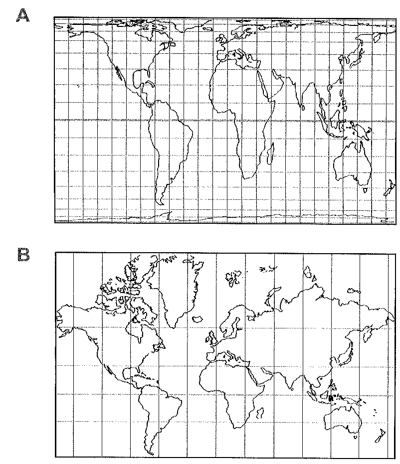
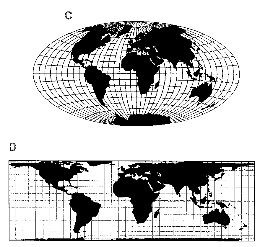
There are more drawings than names so you will not use all of them.
37. Mercator projection
38. Aitoff projection
39. Peters projection
Question 40
Choose the correct letter A-D.
40. The main point made by the writer of this article is that we need to …
- understand maps.
- understand map-making.
- understand that maps are not objective.
- understand the importance of latitude and longitude.
Answers for Map wars with Explanations
The Map wars reading answers with explanations is provided below. They will help you in assessing your reading skills and band score.
28. Answer: projection
Explanation: Located in paragraph B, 3rd line - This is where the problems start since you cannot project three-dimensional information onto a flat plane without making certain assumptions.
29. Answer: axis
Explanation: Located in paragraph C, 5th line - Such a map demonstrates what is called ‘fidelity of axis’.
30. Answer: perspective
Explanation: Located in paragraph G, 2nd line - gave a euro-centric view of the world.
31. Answer: compare
Explanation: Located in paragraph G, 5th line - Dr. Peters insisted that his map, which first appeared in 1985, has equal-area projection so that no country is given prominence over another, plus fidelity of axis to avoid the disorientating effect of bent lines of latitude and longitude.
32. Answer: M
Explanation: Located in paragraph F, 6th line - More importantly the relative sizes of intermediate areas are completely distorted; South America seems smaller than Europe whereas in fact it is twice the size.
33. Answer: M
Explanation: Located in paragraph F, 8th line - These changes in scale distort both the size and shape of countries.
34. Answer: P
Explanation: Located in paragraph H, 5th line - Dr. Peters decided that the minimum distortions should occur not at the equator but at the 45 degree lines of latitude, as these are much more populated areas.
35. Answer: M
Explanation: Located in paragraph F, 1st line - To make it work, the further away you get from the equator, the further apart you have to move the horizontal lines of latitude.
36. Answer: A
Explanation: Located in paragraph F 10th line - One of the best known of these is the Aitoff projection of 1889, which attempted to represent country sizes and shapes more correctly.
37. Answer: B
Explanation: Located in paragraph F, 3rd line - As these distances increase so do the sizes of the countries underneath them. So, by the time you get to the North or South Poles the lines would be drawn infinitely far apart and the Arctic and Antarctic regions can scarcely be represented at all since they would be infinitely large.
38. Answer: C
Explanation: Located in paragraph F, 10th line - One of the best known of these is the Aitoff projection of 1889, which attempted to represent country sizes and shapes more correctly. But to do so required a compromise - the lines of latitude and longitude had to be ‘bent’.
39. Answer: A
Explanation: Located in paragraph G, 3rd line - It shrank the developing countries since most of these are around the equator, and it expanded the richer countries since they lay further north. Even the equator itself is shown two thirds of the way down on the traditional Mercator map.
40. Answer: C
Explanation: Located in paragraph J, 3rd line - But it isn’t recommended that you navigate a '747’ round the world with the Peters projection or with any other single global projection they would all lead you astray!
Other Reading Tests

About Author Manimegalai Samidurai
Manimegalai is a multifaceted professional, excelling as an author, writer, and study-abroad expert. Her vast knowledge of English proficiency exams, including IELTS, GRE, SAT, and PTE, and exceptional content writing skills make her a go-to resource for students seeking guidance and support in their foreign education journey. She is a trusted authority in writing content related to these test-prep exams, making her an invaluable resource for those seeking guidance. With her well-researched and informative blogs, articles, and study materials, Manimegalai has helped countless students achieve their desired band scores and get admissions to top-notch colleges & universities in countries like Canada, USA, UK, Australia, Ireland, etc.
Kanan.co is a trusted study abroad consultancy offering comprehensive services, resources, and solutions for students and education institutions. We support students at every stage of their global education journey, ensuring a smooth and guided experience. Along with test preparation for IELTS, GRE, TOEFL, and SAT, we provide expert services such as SOP writing, visa guidance, accommodation support, scholarship assistance, and education loan support. Our expertise and commitment to excellence make us a reliable partner for students pursuing international education.
Free Online Mock Test 2026
Practice our mock test worth Rs. 25000 for Free and know your IELTS score!








Global Headquarters
Kanan Int EdTech Inc
320 Bay Street, Suite 321 (Spaces), Toronto ON, Canada M5B 1N9
Indian Headquarters
Kanan International Pvt. Ltd.
D-wing, 2nd Floor, Trident Complex, Ellora Park Vadiwadi Road, Vadodara, Gujarat 390007
IT/ Digital Campus
Kanan International Pvt. Ltd
Old, New No 3, 2nd Floor, 1A, Dr Sadasivam Rd, T. Nagar, Chennai, Tamil Nadu 600017
Our branches
- Bardoli
- Bharuch
- Chennai
- Dehradun
- Gurugram
- Himatnagar
- Karnal
- Nadiad
- Navsari
- Palanpur
- Rajkot
- Vadodara
- Valsad
- Vallabh Vidyanagar
- Vapi
Study Abroad
Test Prep
Top Universities
Consultants
IELTS Centers
GRE Centers
TOEFL Centers
SAT Centers
Language Courses in Vadodara
SOP Blogs
Featured Blogs
Study Abroad Consultants in Chennai
Study Abroad Consultants in Surat
Study Abroad Consultants in Navsari
Study Abroad Consultants in Bardoli
Study Abroad Consultants in Ahmedabad
Study Abroad Consultants in Anand
Study Abroad Consultants in Khanna
Study Abroad Consultants in Nadiad
Study Abroad Consultants in Vadodara
Study abroad consultants in Valsad
Copyright © 2026 KANAN.CO All rights reserved.