- Study Abroad
- / ielts
- / crossing the humber estuary reading answers
Crossing the Humber Estuary Reading Answers


Author
17-09-2025

In this article we have given Crossing the Humber Estuary reading answers, with questions, answers with explanations. This article has 13 questions based on the passage in 2 different types namely - 7 questions as matching headings and 6 questions as summary completions.
Check out our YouTube Channel to Practice Full-Length IELTS Reading Tests Daily

Table of content:
- Solution for Crossing the Humber Estuary
- Crossing the Humber Estuary IELTS reading practice test
- Passage
- Questions
- Answers with explanation
Solution for Crossing the Humber Estuary
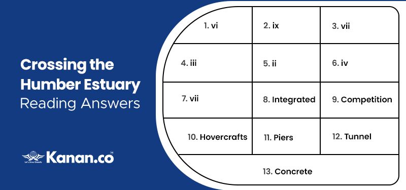
Below, we have given the answers for Crossing the Humber Estuary reading answers in table form.

Answer Table
| 1. vi | 4. iii | 7. vii | 10. Hovercrafts | 13. Concrete |
| 2. ix | 5. ii | 8. Integrated | 11. Piers | |
| 3. vii | 6. iv | 9. Competition | 12. Tunnel |
Crossing the Humber Estuary IELTS reading practice test - Exam Review
We have provided the Crossing the Humber Estuary IELTS reading answers, this article will help you to crack your major exams with band scores. Go through the given passage completely and answer the questions.
Passage
Here we have given the Crossing the Humber Estuary reading answers with location. Read the entire passage and answer your questions.
Crossing the Humber Estuary reading answers
- For thousands of years, the Humber, an estuary formed where two major rivers, the Trent and the Ouse, meet- has been an obstacle to communications along the east coast of England, between the counties of Yorkshire to the north and Lincolnshire to the south. Before the arrival of the railways in the 19th century, water transportation was the most efficient means of moving heavy or bulk freight, and the Humber, situated at the heart of the waterway system associated with the two major rivers, was one of the chief highways of England its traffic brought prosperity to the settlements on its banks, particularly the city of Hull on its north bank, but the river itself tended to cut them off from some of their closest neighbors, as well as obstructing the progress of travelers moving north or south.
- To cater for these local and, as time progressed, wider needs, ferries were provided across many of the streams flowing into the Humber, and in 1315, a ferry was established across the Humber itself between Hull and Lincolnshire. By 1800, this ferry had become fully integrated into the overland transport system, but the changes associated with the industrial revolution were soon to threaten its position, increased traffic encouraged speculators to establish rival ferries between Hull and Lincolnshire, notably a service between Hull and New Holland which opened in 1826. This crossing was considerably shorter than on the existing Hull to Barton service, which closed in 1851, unable to cope with the increased competition from the rival service.
- The New Holland ferry service then grew into a major link between the north and south banks of the Humber, carrying passengers and cattle and goods bound for Hull Market. In 1968, there was briefly a ferry service from Grimsby to Hull involving Hovercrafts. This did not last long as the novercrafts could not cope with the demands of the River Humber. The ferry service between Hull and New Holland ended with the opening of the Humber Bridge in 1961.
- The bridge was the outcome of over 100 years of campaigning by local interests for the construction of a bridge or funnel across the estuary. The first major crossing proposal was a tunnel scheme in 1872. This scheme was promoted by Hull merchants and businesses dissatisfied with the service provided by the New Holland ferry crossing .Over the next 100 years a variety of services were provided by the New Holland ferry crossing. Over the next 100 years, a variety of proposals were put forward in an effort to bridge the Humber, in 1928, a plan was drawn up by Hull City Council to build a multi-span bridge four miles west of Hull. However the scheme was dropped after being hit by the financial woes of the Great Depression of the late 1920s and early 1930s.
- Government approval for the construction of a suspension bridge was finally granted in 1959, although it was not until 1973 that work finally began. The reasons why a suspension bridge was chosen were twofold. Firstly, the Humber has a shitting bed, and the navigable channel along which a craft can travel is always changing; a suspension bridge with no support piers in mid-stream would not obstruct the estuary. Secondly, because of the geology and topography of the area, the cost of constructing a tunnel would have been excessive.
- Work on the construction proceeded for eight years, during which time many thousands of tonnes of steel and concrete were used and upwards of one thousand workers and staff were employed at times of peak activity. The designers had been responsible for two other major suspension bridges in Britain but, with a total span of 2.220 m, or almost a mile and a half, the Humber was going to be the longest suspension bridge in the world. Nowadays designers have computers, but back then everything was done with slide rules and calculators. The towers were concrete rather than the usual steel, since concrete was cheaper and would blend in better with the setting. The bridge was designed to stand for 120 years.
- Malcolm Stockwell, the bridgemaster, recalls that when the bridge first opened, there wasn’t a great deal of interest in it. Then children started visiting, and he remembers their astonishment at seeing the control room and all the lights. People who lived in towns on opposite banks a mile apart started crossing the river- a journey that previously might as well have been to the moon. The bridge brought them together.
- The bridge opened up, both socially and economically, two previously remote and insular areas of England, and the improvement in communication enabled the area to realize its potential in commercial, industrial and tourist development. The bridge has saved many millions of vehicle miles and many valuable hours of drivers’ and passengers’ time – an important factor not only for the drivers and operators of commercial vehicles, but also for tourists and holidaymakers who would have had to travel around the estuary to reach destinations in the region. The words of Malcolm Stockwell,’Although it can’t beat the Golden Gate Bridge San Francisco for setting, far outstrips it for sheer elegance and as a piece of engineering’.
Questions
Questions 1 – 7
- The text has seven sections, A-G
- Choose the correct heading for each section from the list of headings below.
- Write the correct number, i-ix, in boxes 1-7 on your answer sheet.
List of Headings
- Why the ferry crossing has always been difficult
- Building the bridge
- An advantage of the design for the bridge
- The growing popularity of the bridge
- Opposition to building a bridge
- Benefits and disadvantages the Humber has brought
- Proposed alternatives to ferry services
- How the bridge has contributed to the region’s
- Rising demand for river transport
1. Section A
2. Section B
3. Section C
4. Section D
5. Section E
6. Section F
7. Section G
Questions 8 – 13
- Choose one word only from the text for each answer.
Crossing the Humber
The first ferry across the Humber started operating in 1315, and by 1800, this service had been 8…………… with other forms of transport. The mid 19th century saw greater 9…………… In the provision of services. In 1968, an attempt to establish a service across the river using 10………… failed. The Humber Bridge is a suspension bridge because the channel that ships travel along supporting a bridge would obstruct its A bridge rather than move, and 11 ………….. than a 12………… was chosen on the grounds of cost. This was also one reason why 13………….. was used for the towers.
Answers for Crossing the Humber Estuary with Explanation
In this portion we have given Crossing the Humber Estuary reading answers with explanation, this section will help you to identify your mistakes while answering.
1. Answer: vi
Explanation: “The Humber, an estuary formed where two major rivers, the Trent and the Ouse, meet- has been an obstacle to communications along the east coast of England, between the counties of Yorkshire to the north and Lincolnshire to the south. Before the arrival of the railways in the 19th century”. With this line it is clear that paragraph A states about the benefits and disadvantages the Humber has brought. Hence the given answer is located in the first 4 lines of paragraph A.
2. Answer: ix
Explanation: “By 1800, this ferry had become fully integrated into the overland transport system, but the changes associated with the industrial revolution were soon to threaten its position, increased traffic encouraged speculators to establish rival ferries between Hull and Lincolnshire”. With this line it is clear that paragraph B states about Rising demand for river transport. Hence the given answer is located in the 4-7 lines of paragraph B.
3. Answer: vii
Explanation: “Over the next 100 years, a variety of proposals were put forward in an effort to bridge the Humber, in 1928, a plan was drawn up by Hull City Council to build a multi-span bridge four miles west of Hull”. With this line it is clear that paragraph D states about proposed alternatives to ferry services. Hence the given answer is located in the 6-8 lines of paragraph D.
4. Answer: iii
Explanation: “The reasons why a suspension bridge was chosen were twofold. Firstly, the Humber has a shitting bed, and the navigable channel along which a craft can travel is always changing; a suspension bridge with no support piers in mid-stream would not obstruct the estuary. Secondly, because of the geology and topography of the area, the cost of constructing a tunnel would have been excessive”. With this line it is clear that paragraph E states about an advantage of the design for the bridge. Hence the given answer is located in the 2-7 lines of paragraph E.
5. Answer: ii
Explanation: “Work on the construction proceeded for eight years, during which time many thousands of tonnes of steel and concrete were used and upwards of one thousand workers and staff were employed at times of peak activity”. With this line it is clear that paragraph F states about building the bridge. Hence the given answer is located in the first 3 lines of paragraph F.
6. Answer: iv
Explanation: “Malcolm Stockwell, the bridgemaster, recalls that when the bridge first opened, there wasn’t a great deal of interest in it. Then children started visiting, and he remembers their astonishment at seeing the control room and all the lights”. With this line it is clear that paragraph G states about the growing popularity of the bridge. Hence the given answer is located in the first 3 lines of paragraph G.
7. Answer: vii
Explanation: “The bridge has saved many millions of vehicle miles and many valuable hours of drivers’ and passengers’ time – an important factor not only for the drivers and operators of commercial vehicles, but also for tourists and holidaymakers who would have had to travel around the estuary to reach destinations in the region”. With this line it is clear that paragraph G states about alternatives to ferry services. Hence the given answer is located in the 4-7 lines of paragraph H.
8. Answer: integrated
Explanation: “By 1800, this ferry had become fully integrated into the overland transport system”. With this line it is clear that the first ferry across the Humber started operating in 1315, and by 1800, this service had been integrated with other forms of transport. Hence the given answer is located in the fourth line of paragraph B.
9. Answer: competition
Explanation: “This crossing was considerably shorter than on the existing Hull to Barton service, which closed in 1851, unable to cope with the increased competition from the rival service”. With this line it is clear that the mid 19th century saw greater competition in the provision of services. Hence the given answer is located in the last 3 lines of paragraph B.
10. Answer: Hovercrafts
Explanation: “ In 1968, there was briefly a ferry service from Grimsby to Hull involving Hovercrafts”. With this line it is clear that in 1968 an attempt to establish a service across the river using hovercrafts failed . Hence the given answer is located in the 3-4 lines of paragraph C.
11. Answer: piers
Explanation: “Firstly, the Humber has a shitting bed, and the navigable channel along which a craft can travel is always changing; a suspension bridge with no support piers in mid-stream would not obstruct the estuary”. With this line it is clear that the Humber Bridge is a suspension bridge because the channel that ships travel along supporting a bridge would obstruct its A bridge rather than move, and piers. Hence the given answer is located in the 3-7 lines of paragraph E.
12. Answer: Tunnel
Explanation: “Secondly, because of the geology and topography of the area, the cost of constructing a tunnel would have been excessive”. With this line it is clear that the Humber Bridge is a suspension bridge because the channel that ships travel along supporting a bridge would obstruct its A bridge rather than move, and piers than a tunnel was chosen on the grounds of cost. Hence the given answer is located in the last 2 lines of paragraph E.
13. Answer: Concrete
Explanation: “The towers were concrete rather than the usual steel, since concrete was cheaper and would blend in better with the setting. The bridge was designed to stand for 120 years”. With this line it is clear that this was also one reason why concrete was used for the towers. Hence the given answer is located in the last 3 lines of paragraph F.
Other reading answers

About Author Manimegalai Samidurai
Manimegalai is a multifaceted professional, excelling as an author, writer, and study-abroad expert. Her vast knowledge of English proficiency exams, including IELTS, GRE, SAT, and PTE, and exceptional content writing skills make her a go-to resource for students seeking guidance and support in their foreign education journey. She is a trusted authority in writing content related to these test-prep exams, making her an invaluable resource for those seeking guidance. With her well-researched and informative blogs, articles, and study materials, Manimegalai has helped countless students achieve their desired band scores and get admissions to top-notch colleges & universities in countries like Canada, USA, UK, Australia, Ireland, etc.
Kanan.co is a trusted study abroad consultancy offering comprehensive services, resources, and solutions for students and education institutions. We support students at every stage of their global education journey, ensuring a smooth and guided experience. Along with test preparation for IELTS, GRE, TOEFL, and SAT, we provide expert services such as SOP writing, visa guidance, accommodation support, scholarship assistance, and education loan support. Our expertise and commitment to excellence make us a reliable partner for students pursuing international education.
Free Online Mock Test 2026
Practice our mock test worth Rs. 25000 for Free and know your IELTS score!








Global Headquarters
Kanan Int EdTech Inc
320 Bay Street, Suite 321 (Spaces), Toronto ON, Canada M5B 1N9
Indian Headquarters
Kanan International Pvt. Ltd.
D-wing, 2nd Floor, Trident Complex, Ellora Park Vadiwadi Road, Vadodara, Gujarat 390007
IT/ Digital Campus
Kanan International Pvt. Ltd
Old, New No 3, 2nd Floor, 1A, Dr Sadasivam Rd, T. Nagar, Chennai, Tamil Nadu 600017
Our branches
- Bardoli
- Bharuch
- Chennai
- Dehradun
- Gurugram
- Himatnagar
- Karnal
- Nadiad
- Navsari
- Palanpur
- Rajkot
- Vadodara
- Valsad
- Vallabh Vidyanagar
- Vapi
Study Abroad
Test Prep
Top Universities
Consultants
IELTS Centers
GRE Centers
TOEFL Centers
SAT Centers
Language Courses in Vadodara
SOP Blogs
Featured Blogs
Study Abroad Consultants in Chennai
Study Abroad Consultants in Surat
Study Abroad Consultants in Navsari
Study Abroad Consultants in Bardoli
Study Abroad Consultants in Ahmedabad
Study Abroad Consultants in Anand
Study Abroad Consultants in Khanna
Study Abroad Consultants in Nadiad
Study Abroad Consultants in Vadodara
Study abroad consultants in Valsad
Copyright © 2026 KANAN.CO All rights reserved.