IELTS Writing Task 1 Map Sample Answers


Author
23-06-2025

The IELTS Task 1 map requires you to describe and compare maps. These maps may depict a location at different time periods (past, present, future) or showcase two different plans or proposals for the same area. You’re required to write the essay by comparing 2 or 3 maps, and in a rare case, you’re asked to analyze a single map. In this task, you need to summarize the main features of the given map. It is suggested that you analyze the features given in the past and then compare them with the present map or you can describe all the key features of both the past and present maps. Based on the time period, you need to use past tense and present tense, vocabulary, language of location, and language of comparison and contrast. In this article, we've given the task 1 map sample answers which help you to know the structure and answer the essay in 150 words.
Check Out our YouTube Channel to Practice Full-Length IELTS Listening Tests Daily

IELTS Task 1 Map Samples
There are three types of map questions you need to analyze before writing the answers
1. Compare two maps - past and present
2. Compare two maps - present and future
3. Describe a single map
Check the below writing task 1 map sample answers to practice well and secure band 9 in the IELTS test.
IELTS Writing Task 1 Map Sample 1
You should spend about 20 minutes on this task.
The maps below show the centre of a small town called Islip as it is now, and plans for its development.
Summarize the information by selecting and reporting the main features, and make comparisons where relevant.
Write at least 150 words.

The map reflects the current structure of the small town called Islip and the expected future development plan of the town.
Overall, the town will get new amenities such as bus stations, shopping centre, car parking, and new housing.
In the east-west of the town centre there is a main road. This main road leads to two side roads. One is heading to the school which is situated in the southwest of Islip and the other is a park in the southeast. In the future plan, the main road will be for pedestrians and the two side roads will be a dual carriageway extending towards the countryside. In the north of the main road, there are shops situated which might be demolished and a bus station, shopping centre, a car park and also some new housing will take place.
The shops that are at the south of the main road will remain there but the housing will be relocated. The portion of the park located nearby will be removed and the new residential buildings will come into place and the school will get extended.
(184 words)
Download the map below show the centre of a small town pdf
IELTS Writing Task 1 Map Sample 2
You should spend about 20 minutes on this task.
Below is a map of the city of Brandfield. City planners have decided to build a new shopping mall for the area, and two sites, S1 and S2 have been proposed.
Summarize the information by selecting and reporting the main features and make comparisons where relevant.
Write at least 150 words.
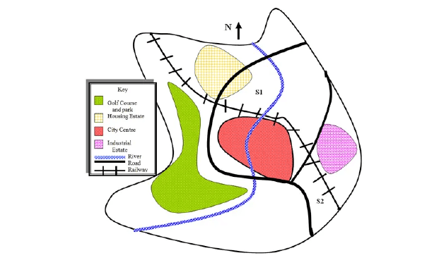
The map illustrates the two proposed sites for the new shopping mall in the city of Brandfield.
By comparing these two sites S1 and S2, it is shown that S1 is located near the residential area whereas S2 is situated near the industrial region.
In the north of the city the first site (S1) is situated close to the city centre and housing estate. There was a railway line passing near the site which is above the city centre. Towards the south, there was a river running through the city centre which is easily accessible by the site. Intersecting the river, there was a road passing through the residential area which is convenient to access from the site.
Site 2 is located far from the housing plots and close to the industrial area. Nearby the site there were two main roads in the west and the railroad in the north east was in place.
(154 words)
Download the below is a map of the city of brandfield pdf
IELTS Writing Task 1 Map Sample 3
You should spend about 20 minutes on this task.
The map below is of the town of Garlsdon. A new supermarket(s) is planned for the town. The map shows two possible sites for the supermarket.
Summarise the information by selecting and reporting the main features, and make comparisons where relevant.
Write at least 150 words.

The map shows the town of Garlsdon which has an overall population of 65,000. There were two locations planned to construct a new supermarket for the town.
The map gives information about the sites of the supermarket where one is located in the countryside and the other is located in the town centre.
Site 1 of the supermarket is situated away from the town centre which is majorly covered by industries. There is no housing nearby, however, those people can reach here by train and transport. The site is in between the railway line and a main road. This site is commutable only by the Hindon people rather than the Brandson and Grandson people who are more in population.
While looking at the second possible site of the supermarket, it is clear that the site is situated in the centre of the town. It is easily reachable by the Brandson and Grandson people and also by the people living in the Hindon by train and from the main road. As this site is located near the residential area it is way more convenient for people to access.
(189 words)
Download the map below is of the town of garlsdon pdf
IELTS Writing Task 1 Map Sample 4
This question is from Cambridge IELTS 13 test 1 writing task 1.
You should spend about 20 minutes on this task.
The two maps below show road access to a city hospital in 2007 and 2010.
Summarize the information by selecting and reporting the main features, and make comparisons where relevant.
Write at least 150 words.

The two maps show how the road access to the city hospital has changed from the year 2007 to 2010.
Overall there are many improvisations held in the facilities over 3 years. The bus stop was converted into a bus station, car parks for staff and the public were separated, and roundabouts were established.
There was a ring road around the city hospital which was connected by the hospital road to the city road in 2007. In 2010, there were two roundabouts installed at the junctions of the hospital road that is between the ring road and the city road. On the two sides of the hospital road, there were 6 bus stops that existed back in 2007. But, in 2010 it was replaced as a single bus station on the west side of the hospital road.
In 2007, there was a car park for both city hospital staff and the public on the southeast side of Ring Road. That car park remained only for staff and a new public car park was built on the east side of the road.
(176 words)
Download the two maps below show road access to a city hospital pdf
IELTS Writing Task 1 Map Sample 5
You should spend about 20 minutes on this task.
The maps below show the village of Stokeford in 1930 and 2010.
Summarise the information by selecting and reporting the main features, and make comparisons where relevant.
Write at least 150 words.
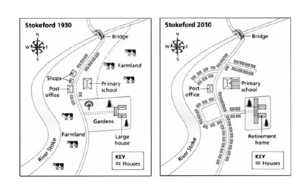
The two maps exhibit the changes and development of the village of Stokeford over the period of 1930 to 2010 that is located in the east Bank of the River Stoke.
The village of Stokeford had a huge development over the period of time. It has transformed from a small village to a developed residential area.
Many construction and development was executed after 1930. The development of housing, new roads, and residential properties came into existence in the farmland which was there in 1930. Due to this evolution and the population growth of the village the primary school building was expanded.
In the Stokeford village, one thing that hasn't changed in the years was the Post office. But, if you see the two shops near the post office located in the north-west of the school didn't exist in 2010. Those shops were replaced by new houses. In 1930, at the south-east of the school there was a garden located where there were large houses situated. But, in 2010 it was converted into a retirement house. These were the notable developments that happened in the village of Stokeford over the years.
(190 words)
Download the maps below show the village of Stokeford in 1930 and 2010 pdf
Also, download IELTS writing task 1 map pdf
How to Write Task 1 Map Essay?
The IELTS writing task 1 map should be written in 4 paragraphs including an introduction, overview, describing the 1st main feature and 2nd key feature.
Below are the steps to write the Task 1 map:
Step 1: Analyzing the question
Step 2: Finding the main features
Step 3: Give an introduction
Step 4: Write an overview
Step 5: Describe the features
Before attempting the IELTS writing task 1 essay task, you need to consider the following tactics.
- Structure and organization: Begin with an introduction and an overview of the maps before getting into the specific details.
- Comparative language: Use terms like "similarly," "in contrast," "whereas," etc., to highlight differences and similarities.
- Accuracy: Ensure precision in your descriptions; misinterpreting the map can lower your score.
- Grammar: Showcase your English proficiency by using a range of grammatical structures.
- Descriptive vocabulary: Use a wide range of words to describe locations, directions, and changes (e.g., north of, adjacent to).
Knowing the IELTS writing task 1 map vocabulary is crucial for writing the essay by using words that involve the tenses, cardinal directions, verbs that describe maps, area, city, landscape, etc. Utilize this article to practice writing the map questions with the right vocabulary to score high in the test.
More Samples of IELTS Maps

About Author Arivarasi
Arivarasi is an experienced author with expertise in the study abroad industry and preparing test materials for exams like IELTS, TOEFL, GRE, SAT, PTE, etc. She stays up-to-date with university and college requirements for international students which allows her to provide guidance on course selection, documents like SOP, LOR, and scholarship opportunities. She has written numerous articles on study abroad exams, destinations, universities & colleges requirements, admission procedures, and the entire process of studying abroad. Collaborating with industry experts and counselors, she crafts informative articles that make students take the right decisions.
Kanan.co is a trusted study abroad consultancy offering comprehensive services, resources, and solutions for students and education institutions. We support students at every stage of their global education journey, ensuring a smooth and guided experience. Along with test preparation for IELTS, GRE, TOEFL, and SAT, we provide expert services such as SOP writing, visa guidance, accommodation support, scholarship assistance, and education loan support. Our expertise and commitment to excellence make us a reliable partner for students pursuing international education.
Free Online Mock Test 2026
Practice our mock test worth Rs. 25000 for Free and know your IELTS score!








Global Headquarters
Kanan Int EdTech Inc
320 Bay Street, Suite 321 (Spaces), Toronto ON, Canada M5B 1N9
Indian Headquarters
Kanan International Pvt. Ltd.
D-wing, 2nd Floor, Trident Complex, Ellora Park Vadiwadi Road, Vadodara, Gujarat 390007
IT/ Digital Campus
Kanan International Pvt. Ltd
Old, New No 3, 2nd Floor, 1A, Dr Sadasivam Rd, T. Nagar, Chennai, Tamil Nadu 600017
Our branches
- Bardoli
- Bharuch
- Chennai
- Dehradun
- Gurugram
- Himatnagar
- Karnal
- Nadiad
- Navsari
- Palanpur
- Rajkot
- Vadodara
- Valsad
- Vallabh Vidyanagar
- Vapi
Study Abroad
Test Prep
Top Universities
Consultants
IELTS Centers
GRE Centers
TOEFL Centers
SAT Centers
Language Courses in Vadodara
SOP Blogs
Featured Blogs
Study Abroad Consultants in Chennai
Study Abroad Consultants in Surat
Study Abroad Consultants in Navsari
Study Abroad Consultants in Bardoli
Study Abroad Consultants in Ahmedabad
Study Abroad Consultants in Anand
Study Abroad Consultants in Khanna
Study Abroad Consultants in Nadiad
Study Abroad Consultants in Vadodara
Study abroad consultants in Valsad
Copyright © 2026 KANAN.CO All rights reserved.